NWS Spokane
@NWSSpokane
Official Twitter account for the National Weather Service Spokane WA. Details: http://weather.gov/twitter
[July 27, 12:15 AM]: We are monitoring scattered light showers and embedded T-storms tracking into the Camas Prairie tonight. #idwx #wawx
4:08PM- Wind forecast through 10 PM local zoomed into northeast WA & northern ID Panhandle where some new wildfire activity has developed this afternoon. Follow local county emergency management for evacuation updates. #wawx #wafire #idwx @waDNR_fire @StevensCountyEM @waEMD
Breezy winds develop Thursday afternoon as temperatures warm into the 90s and humidity levels lower near 20%. Pls be cautious with fire ignitions near dry fuels with elevated fire weather conditions in place. #wawx #idwx
Curious how much rain fell over the last couple of days across the Inland Northwest? Here are the 72 hour rain totals from volunteer observers and weather stations: partnerservices.nws.noaa.gov/products/24102…
Temperatures will return to the 80s and 90s for the remainder of July. After a 2 day break, summer is back! #wawx #idwx

Wednesday will be quiet but fire concerns increase Thursday and Friday with breezy afternoon winds. Areas that did not see rain Monday or Tuesday are the areas of highest concern. #wawx #idwx

[July 22, 8:25PM]: Narrow band of heavy rain is impacting I-90 between Sprague and Ritzville. Cell is moving to the SE. Be prepared for ponding of water on the road and reduced visibility through 9PM. #wawx
![NWSSpokane's tweet image. [July 22, 8:25PM]: Narrow band of heavy rain is impacting I-90 between Sprague and Ritzville. Cell is moving to the SE. Be prepared for ponding of water on the road and reduced visibility through 9PM. #wawx](https://pbs.twimg.com/media/GwgxxHAXUAArQ2-.png)
A special weather statement has been issued for Lost Creek WA until 8:30 PM PDT

A special weather statement has been issued for Deer Park WA, Loon Lake WA and Clayton WA until 7:45 PM PDT

A special weather statement has been issued for Northport WA and Leadpoint WA until 7:30 PM PDT

A special weather statement has been issued for Loon Lake WA, Clayton WA and Springdale WA until 7:15 PM PDT

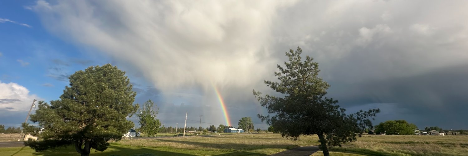
[July 22, 6:15 PM]:]T-storms continue to impact areas of NE WA. These storms have a history of torrential rains, isolated lightning, and small hail. Wind gusts have been up to 20 mph. #wawx #idwx
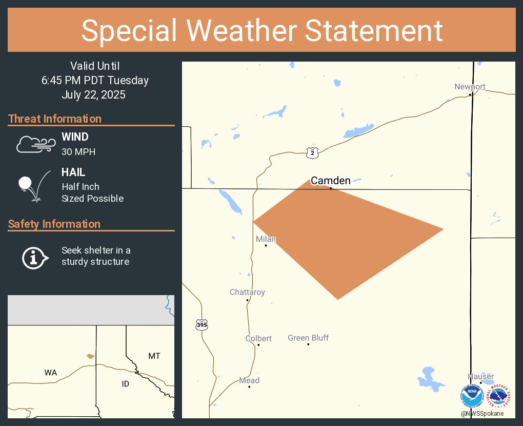
A special weather statement has been issued for Camden WA until 6:45 PM PDT
A special weather statement has been issued for Santa ID and Fernwood ID until 6:45 PM PDT

A special weather statement has been issued for Newport WA, Priest River ID and Oldtown ID until 5:45 PM PDT

A special weather statement has been issued for Saint Joe ID until 5:30 PM PDT

A special weather statement has been issued for Cusick WA, Usk WA and Dalkena WA until 5:15 PM PDT

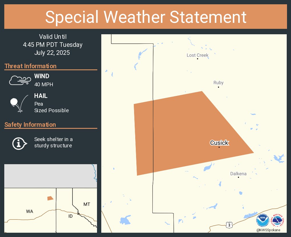
A special weather statement has been issued for Cusick WA and Usk WA until 4:45 PM PDT
A special weather statement has been issued for Ruby WA until 4:15 PM PDT

A special weather statement has been issued for Spokane WA, Spokane Valley WA and Mead WA until 3:15 PM PDT
