
NWS Phoenix
@NWSPhoenix
Official X account for the National Weather Service Phoenix, Arizona. Details: https://www.weather.gov/nws_x
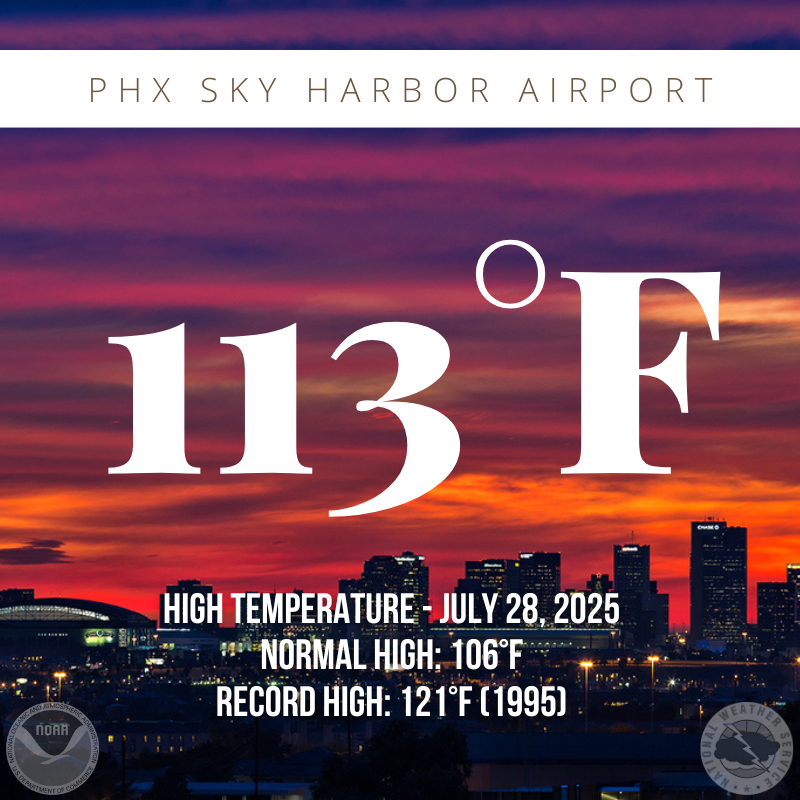
Phoenix Sky Harbor saw a high temperature of 113 degrees today, 7 degrees above normal. Temperatures will continue to float near and/or upwards of 110 degrees this week. #azwx
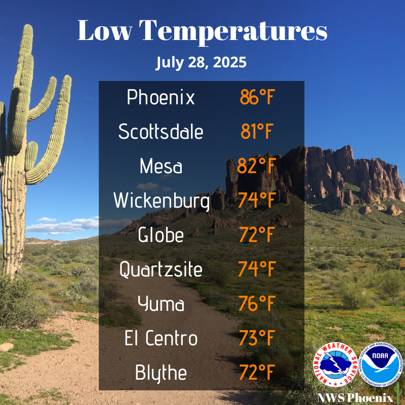
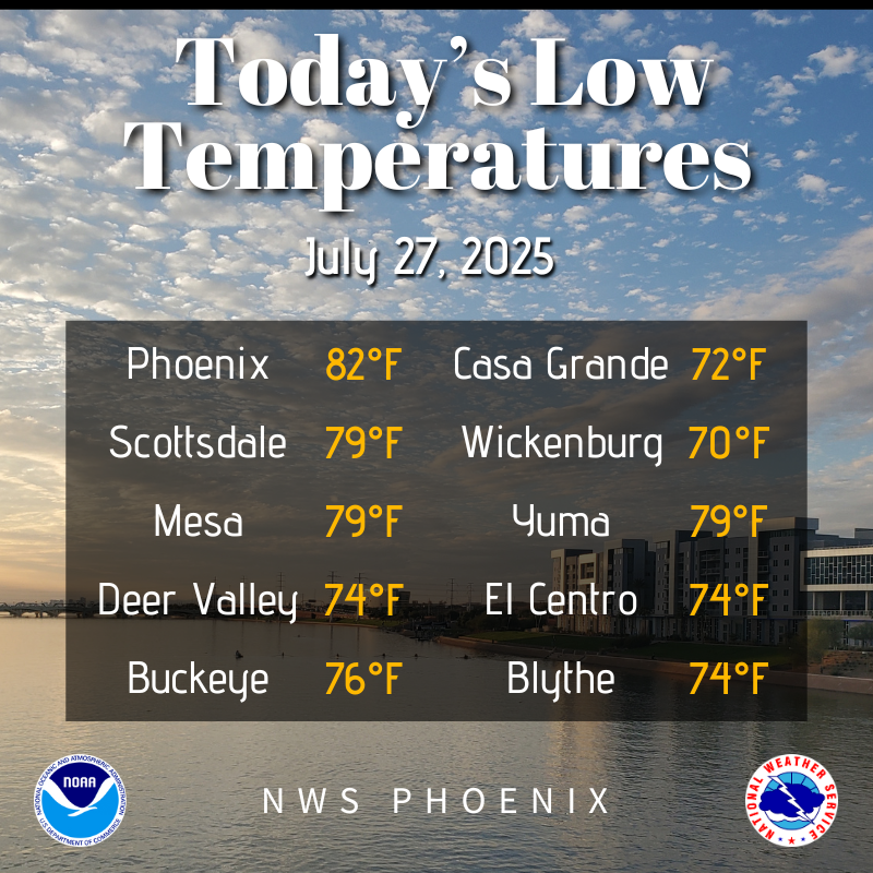
Morning low temperatures across the area were generally in the 70s except for portions of the Phoenix metro, where temps only cooled into the lower to middle 80s overnight. #azwx #cawx
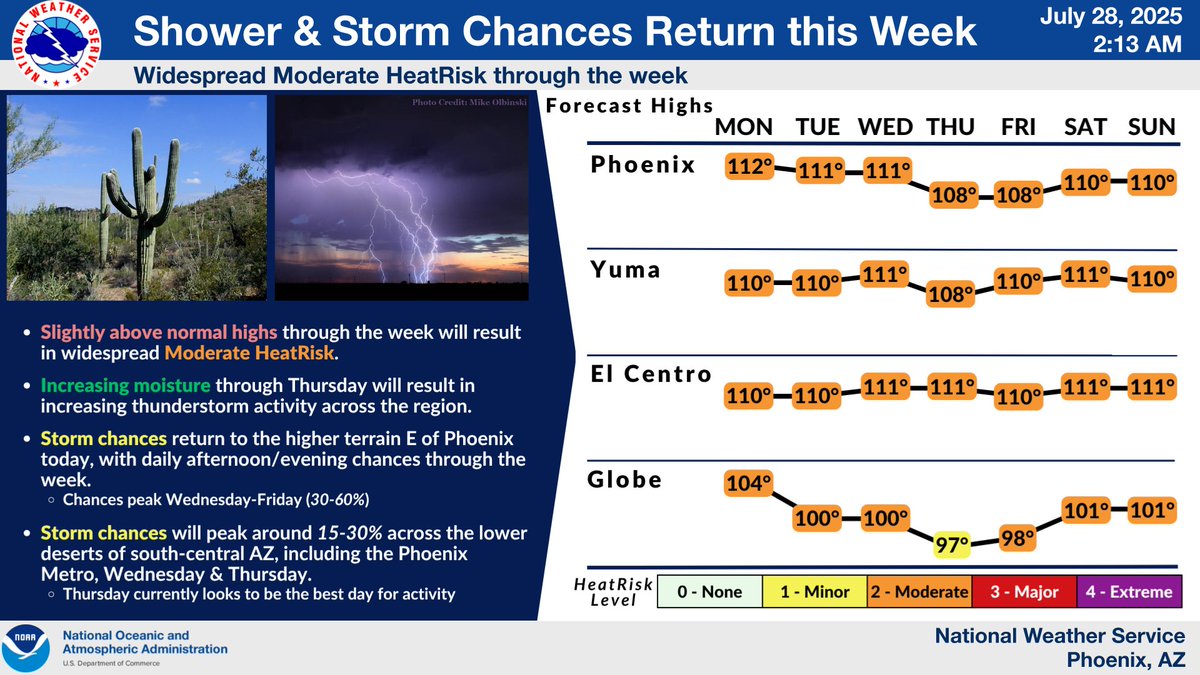
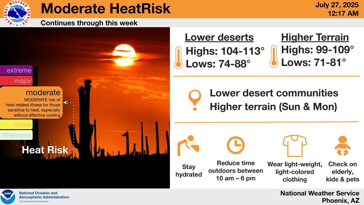
Here's a look at the weather outlook for the week. Shower & storm chances will be increasing through Thursday for the higher terrain and the lower deserts of south-central AZ. Slightly above normal temperatures for the week will result in widespread Moderate HeatRisk. #azwx #cawx
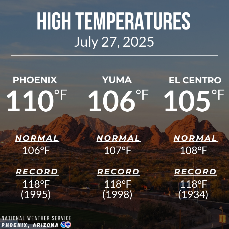
High temperatures across the region this afternoon were near to slightly above normal. #azwx #cawx
Below normal low temperatures again this morning across the region with many areas starting the day in the 70s. #azwx #cawx
Temperatures will be above normal through the week resulting in widespread Moderate HeatRisk. Make sure to take proper precautions, such as limiting your time outdoors and drinking plenty of water. #azwx #caws
High temperatures this afternoon generally were near average across AZ to slightly below average across southeast CA. Slightly warmer daytime highs expected for Sunday. #azwx #cawx

Many of you out there have been saying this has been a lackluster monsoon so far and the data supports that. We have not been able to get good moisture to stick around, due to persistent southwest flow. Rainfall and lightning activity is well below normal for AZ. #azwx #cawx

Low temperatures this morning were below normal, thanks to the dry air and clear skies, with lower deserts mostly in the 70s to around 80°F. #azwx #cawx

Here's a look at the forecasted high temperatures for this afternoon. Near normal temperatures are forecasted for south-central AZ and slightly below normal temps are forecasted for SE CA and SW AZ. Have a great Saturday! #azwx #cawx

Today brought near normal high temperatures with some cities seeing a few degrees above normal. Temperatures will continue to slowly climb throughout the weekend, with the peak expected by Sunday afternoon. #azwx #cawx

Morning low temperatures across the lower deserts were quite mild for late July, in the 70s to around 80°F. Under mostly sunny skies, expect afternoon highs right around normal for the date, generally between 104-108°F for the typically hotter lower desert locales. #azwx #cawx

Very dry air over Arizona will last through the weekend with temperatures at or just above normal. The hottest days are likely to be Sunday-Tuesday with some areas seeing highs of 110°. Eventually, storm chances will enter the region by next Monday or Tuesday. #azwx #cawx

Today's high temperatures were near normal, to slightly below normal in the western portions of our region. However, Moderate HeatRisk continues in the lower desert communities. #azwx #cawx

An unusual late July weather pattern will yield a rare occurrence of widespread dry weather, yet with temperatures near to slightly below normal through the weekend. Warmer temperatures, increasing moisture, and storm chances will begin to return next week. #azwx #cawx

High temperatures across the region ran a few degrees below normal this afternoon. #azwx #cawx

July 23, 2025: Here are your Wednesday morning low temperatures! Sky Harbor at 85 degrees was right at the normal level. #azwx #cawx

Here's a look at the current dew point temperatures across the Valley early this morning. The large spread in dew point temperatures (30s and 40s in the West Valley and 50s and 60s in the East Valley) shows the much drier air pushing in from the west. #azwx

High temperatures today once again were below average across the region with readings ranging between the upper 90s to lower 100s across the lower deserts. #azwx #cawx

A special weather statement has been issued for Gila County, AZ until 7:00 PM MST
