NWS Gaylord
@NWSGaylord
Official X account for the National Weather Service Gaylord, MI. Details: http://weather.gov/nws_x
After some haze today (more Canadian wildfire smoke), a quiet and cool night is on tap with lows dropping into the 40s and 50s areawide. A bit of patchy fog could develop overnight. Warm/muggy weather on the way for the upcoming week. #miwx #northernmichigan

Clouds will increase tonight, with lows in the 50s and 60s. Scattered showers and storms are possible Saturday, as highs climb into the mid-to-upper 80s across much of the area. #miwx

Lingering precipitation will taper off tonight, with occasional showers and storms possible into next week. Temperatures will cool slightly Friday and Saturday before trending warmer, with highs climbing into the 90s by early next week. #miwx

1230 PM - Strong to severe thunderstorms continue across portions of Otsego and Cheboygan counties and will continue to the northeast. Strong to locally damaging winds and heavy rain are the main concerns with this activity. #miwx
Warm and humid today, with some areas near Saginaw Bay likely seeing heat indices near a 100° this afternoon. Along with that heat and humidity with be scattered showers and thunderstorms, with the greatest threat for storms expected to remain south of the big bridge. #MIwx

8:42 PM ET 7/23/25 Update: A line of strong storms will move into northwest lower Michigan this evening. The primary threat will be strong wind gusts and lightning. #miwx

Storm chances, including potential for severe storms, build into Thursday. Best shot for storms thru tonight will be across the Straits into eastern upper, shifting into northern lower Thursday. Humid with lows 65 -75 tonight, remaining hot / humid Thu. in northern lower. #MIwx


Increasingly hot and humid the next couple days, along with scattered rain/storm chances. Some could be strong with heavy rain. Stay tuned for updates, as exact details on where storms will develop will depend on what happens in the next 12-24hrs. #miwx #northernmichigan

Oh snap! Hot and humid weather returns this week, as highs make a run into the 90s, esp by Thursday. Shower and storm chances return as well -- stay tuned, and do your best to stay cool. #miwx #northernmichigan #90s

Generally quiet weather expected through Tuesday, but it will become increasingly hot and humid with the potential for showers and storms Wednesday and Thursday. Thursday will be the hottest day of the week, with temperatures in the mid 80s to mid 90s. #MIwx

Dry through Tuesday, then increasing temperatures and humidity Wednesday and Thursday. It will feel like temperatures in the 90s. The increase in humidity will bring the potential for an active pattern, with showers and thunderstorms possible.
8:20 PM EDT Radar Update: a frontal boundary is pushing through this evening. Storms are firing along it as it moves across MI. The primary threat with storms is heavy rain, with some having lightning. Gusty outflow winds (up to 40 mph) could also be seen with some storms
After shower/storm chances exit northern MI later this evening, dry conditions prevail Sunday into early next week. The next chance for showers and storms arrives as early as Tuesday night. Temperatures steadily increase as well, with increasing humidity mid next week.

Showers and storms are expected to become more numerous this afternoon afternoon and evening hours. An isolated strong to severe storm remains possible through this time frame.
Showers/storms expected across N MI later this AM and into the PM. Isolated strong storms possible, mainly south of M-32. Primary hazards with any stronger storms will be locally heavy rain & damaging winds, but marginal hail and an isolated tornado cannot be ruled out. #MIwx

Clouds increase tonight, with scattered rain/storms moving in along/ahead of a cold front Sat. Stay weather aware if you have outdoor plans. Quiet weather returns Sunday. #miwx #northernmichigan

Curious how chilly it was last night? Here's a sampling of some of the overnight lows. Your exact location could have been warmer or colder based on things like being at the top/bottom of a hill, in a valley, upwind of a body of water, etc. #miwx #northernmichigan

Warm days, cool nights will be the theme over the next couple days through the weekend. Dry today and Sunday, but chances for showers and some storms on the increase on Saturday. Swim risk will remain low through the weekend.


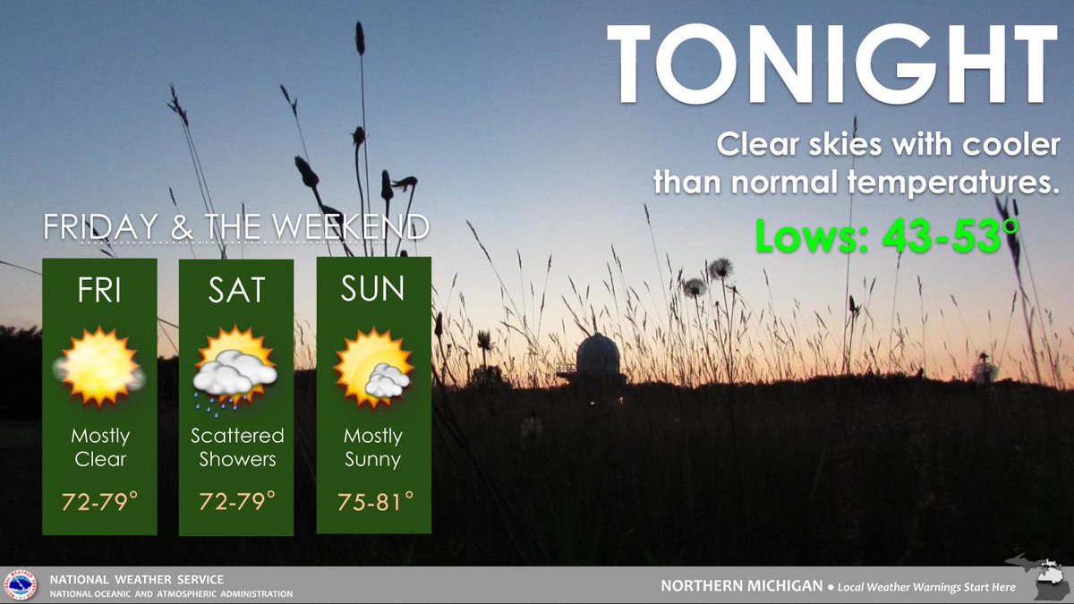
Cloud cover will quickly clear this evening resulting in chilly overnight temperatures. Expect lows in the 40s followed by mostly sunny skies and highs in the mid 70s this Friday. Chances of precipitation return this Saturday as scattered showers move across Michigan.
RADAR UPDATE 11:15 PM: Widespread heavy rain is spreading west to east across the region. Observations display 2”+ of accumulations and reduced visibilities with this line. Manistee to Alpena and south continue to be the main area of concern for potential flooding. #miwx