
NWS GSP
@NWSGSP
Official X Account for National Weather Service Greenville-Spartanburg, SC. Details: http://weather.gov/nws_x.

Heat index values of 100°F-110°F are likely each afternoon from Friday through Wednesday across the Piedmont & foothills. This will be a long-duration heat wave, so be sure to remain hydrated by drinking water & stay indoors in air conditioning when possible. #scwx #ncwx #gawx
Spotlight on the Southeast, which has seen pockets of dryness (and drought in AL) pop up and expand over the last month. Precipitation deficits over the past 30 days combined with the incoming heat wave may cause dryness to expand or intensify. drought.gov @NOAA
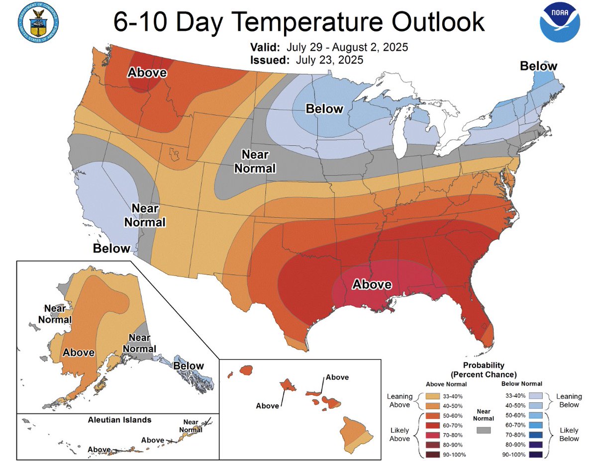
It's going to be hot for the next week. 🥵 If you plan to spend time outside working or playing, check the forecast at weather.gov before you go, and check out the safety tips at weather.gov/heat!

A warming trend will begin today that will lead into another heat wave this weekend into next week. Highs "only" in the lower 90s across the Piedmont. Little in the way of precip today, with just isolated storms possible in the southern part of the area. #ncwx #scwx #gawx

Enjoy the brief "cooldown" today and tomorrow because the heat ramps back up this weekend into early next week. #scwx #ncwx #gawx
The GSP Airport has reached 90°F once again for a high temperature, which extends the streak to 33 consecutive days (Tied for 2nd all-time). The forecast high for Thursday is 90°F, so we will come close to breaking or extending the streak once again. #scwx #ncwx #gawx

The pattern currently resembles a dry warm season wedge, and you can tell by the lack of instability (AKA thunderstorm fuel) across the area. Temperatures and humidity are slightly cooler today compared to the past month or so. Link: spc.noaa.gov/exper/mesoanal… #scwx #ncwx #gawx

ON THIS DATE, 28 YEARS AGO: The remnants of Hurricane Danny moved across the region, producing heavy rain and a few tornadoes. The all-time 24-hour record rainfall for the Charlotte area (6.88") was set. Flash flooding killed 3 and injured 4 near the CLT area. #scwx #ncwx #gawx


Seasonable weather for late July will continue today with temperatures around normal along with the potential for a couple isolated thunderstorms across the mountains this afternoon. #ncwx #scwx #gawx

The max temp at the GSP airport has reached or exceeded 90°F for 32 consecutive days. The record sits at 38 days (1993). Slightly cooler air on Wednesday & Thursday may allow highs to fall short of 90°F each afternoon. Will we break the record at GSP? Stay tuned. #scwx #gspwx

ON THIS DATE, 25 YEARS AGO: Severe thunderstorms across Upstate South Carolina produced a microburst with an 80 MPH wind gust in Greenville County near Mauldin damaged the control tower and several buildings at the Donaldson Center Airport. #scwx #gvlwx

During hot and humid weather, your body's ability to cool itself is challenged in ways you may not expect. Stay #WeatherReady by learning the symptoms of Extreme Heat exposure and the appropriate responses. Link: weather.gov/safety/heat-il… #scwx #ncwx #gawx

A weak front moving through the area today will bring slightly cooler temperatures along with the chance for afternoon/evening thunderstorms, especially across the western half of the area. #ncwx #scwx #gawx

A special weather statement has been issued for Six Mile SC and Salem SC until 8:15 PM EDT

A special weather statement has been issued for Kingstown NC and Lattimore NC until 8:00 PM EDT

A special weather statement has been issued for Laurens County, SC until 6:30 PM EDT

A special weather statement has been issued for Rosman NC until 6:30 PM EDT

A special weather statement has been issued for Laurens County, SC until 6:30 PM EDT

Animals can die of heatstroke within 15 minutes, and cracking the car windows doesn’t help. NEVER leave your pets in parked vehicles. Link: weather.gov/safety/heat-ch… #scwx #ncwx #gawx
