
NWS Columbia
@NWSColumbia
Official X account for the National Weather Service forecast office in West Columbia, SC serving the Midlands of South Carolina and the CSRA of Georgia.
Heat Indices continue to rise each day to around 110F. A Heat Advisory remains in place today with another one for in place Sunday. With the persistent heat and slightly higher heat indices Monday, an Extreme Heat Watch is in place for Monday. Continue to practice heat safety!

A Heat Advisory is in place for Saturday, July 26th from 11am to 9pm. High temperatures will reach near 100°F with heat indices rising to around 109°F. Practice heat safety if you are spending time outdoors and make sure to stay hydrated! #scwx #gawx

A special weather statement has been issued for Orangeburg SC, Bamberg SC and Denmark SC until 5:00 PM EDT

Heat will build over the area this weekend with the hottest stretch of the summer so far with multiple days of max heat indices between 105-110F continuing into next week. Heat-related illness and death occurs every year (even in SC and GA!) Remember to practice heat safety!

Scattered to numerous showers and thunderstorms are expected today, with the greatest coverage across the eastern Midlands and lower Central Savannah River Area (CSRA). Mostly sunny with very low rain chances into the weekend, with temperatures on the rise each day.

Today will feel less humid outside as drier air spreads into the region. The dew point is a good indicator of how "dry" or "humid" it feels outside. So while high temperatures will be around 90 in most areas this afternoon, the lower dew points will make it feel more comfortable.

A special weather statement has been issued for Martinez GA, Aiken SC and Evans GA until 11:00 PM EDT

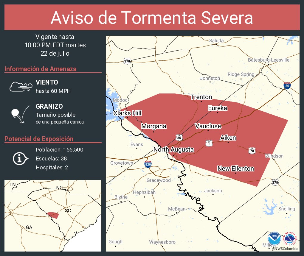
Aviso de Tormenta Severa continúa Aiken SC, North Augusta SC, Belvedere SC hasta las 10:00 PM EDT
Severe Thunderstorm Warning continues for Aiken SC, North Augusta SC and Belvedere SC until 10:00 PM EDT

Aviso de Tormenta Severa incluye Aiken SC, North Augusta SC, Belvedere SC hasta las 10:00 PM EDT

Severe Thunderstorm Warning including Aiken SC, North Augusta SC and Belvedere SC until 10:00 PM EDT

A special weather statement has been issued for Martinez GA, Aiken SC and Evans GA until 10:00 PM EDT

Aviso de Inundación Repentina incluye Batesburg-Leesville SC, Gilbert SC, Summit SC hasta las 11:15 PM EDT

Flash Flood Warning including Batesburg-Leesville SC, Gilbert SC and Summit SC until 11:15 PM EDT

A special weather statement has been issued for Lexington SC, Oak Grove SC and Red Bank SC until 9:15 PM EDT

A special weather statement has been issued for Columbia SC, Lexington SC and West Columbia SC until 8:30 PM EDT
