Nick Stewart
@NStewWX
Spaceflight meteorologist/Upper Level Wind Analyst. 9x Emmy and a 2xMurrow-awarded met/storm chaser/rocket reporter formerly @iowasnewsnow/@KHQA. AMS CBM #896.
After manual quality control, I found the longest strike in my records since I started researching central Florida lightning data. This intracloud strike traveled 57km from north to south, hopping along a convective outer rainband. Ended up over Cape Canaveral SFS! #FLwx
There were plenty of long crawling intracloud lightning strikes as Invest #93L approached the Florida Space Coast early Tuesday morning. Several strikes were well mapped out by Cape MERLIN. #FLwx
Absolute master class in creating a sequel. Followed the Top Gun: Maverick formula perfectly.
Who’s watching Happy Gilmore 2 tonight?
🚀 A moment 8 years in the making: @NASA's TRACERS mission, the largest externally funded research project in the history of the University of Iowa, will launch tomorrow from Vandenberg Space Force Base in California. The launch window is 1:13 p.m. to 2:11 p.m. CDT. 🪐
Fairly benign lightning day across central Florida with the majority of the 4,000 strikes with one severe thunderstorm that drifted southward just inland of the Atlantic coast. #FLwx
This evening's balloon from Cape Canaveral SFS had a 1000-500hPa thickness above the 90th percentile. Not surprising with the high-end heat over central Florida today. Similarly the freezing level was at nearly 5km - also in the 90th percentile. #FLwx


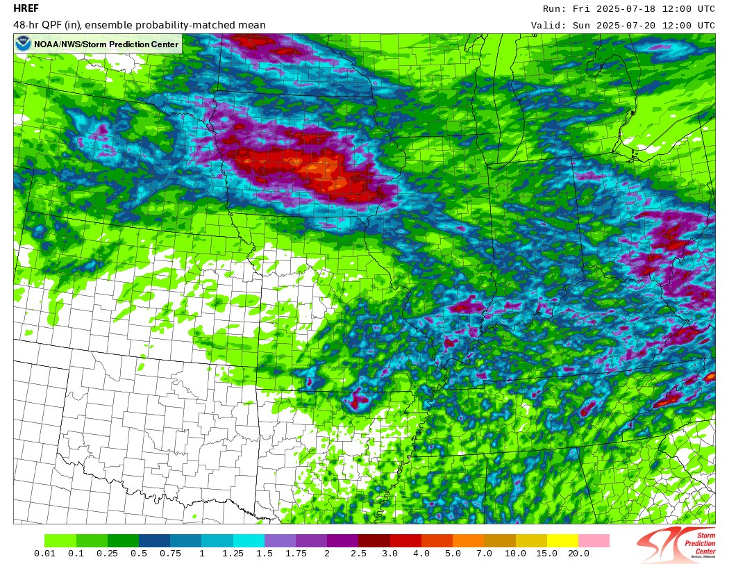
The Ring of Fire pattern over the Midwest takes over starting tonight. HREF ensemble members are indicating some potentially significant rainfall across Iowa over the next two nights. Flash Flooding is certainly on the table, especially following recent heavy rains. Most…

There were plenty of long crawling intracloud lightning strikes as Invest #93L approached the Florida Space Coast early Tuesday morning. Several strikes were well mapped out by Cape MERLIN. #FLwx


Latest update from the National Tsunami Warning Center confirms a tsunami and impacts are expected to portions of Alaska. Details on the observation were not included.

Last week's severe weather in Iowa added enough tornadoes to bring it tied for the least year-to-date, since 1980 (16), based on preliminary surveys. Remarkable given the record was just last year (108 YTD). #IAwx

A look at the tropospheric winds over the Cape via the KSC TDRWP as the center of #93L passed just to the north.

Precipitable water came in at 2.44" this morning at Cape Canaveral SFS ahead of #93L. This is the second-highest for the date and sixth-highest on record for July (since 1950). Very heavy rain will be associated with any showers and storms today across central Florida. #FLwx
