MeteopressEN
@MeteopressEN
We do solid-state weather radars and AI 📡
🌩️Our meteorologists are currently tracking thunderstorms in northern Czechia using a mobile X-band radar.📡

📡Our storm chasers are currently tracking thunderstorms in northern Austria with a mobile X-band radar.

📡Today, our meteorologists captured a notable storm near Pardubice, Czechia, using our mobile X-band weather radar. Mobile weather radars offer higher resolution than standard radars, allowing meteorologists to better localize and forecast the severe weather phenomena in storms.

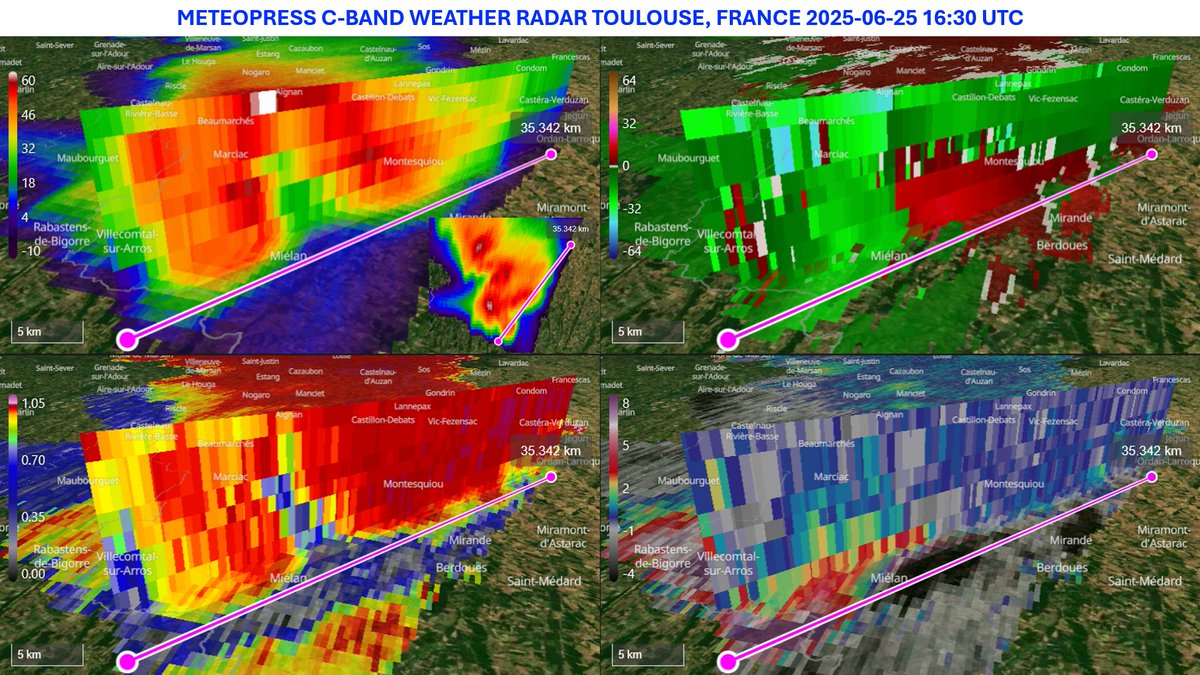
📡Our weather radar in Toulouse, France, captured some impressive backbuilding thunderstorms on Saturday.⛈️
⛈️The supercell that occurred on 25 June 2025 near Toulouse, France, featured a textbook Weak Echo Region (WER). A vertical cross-section through the storm clearly shows rotation in the mesocyclone and low RhoHV values within the updraft.📡
One of the supercells in southern France last week produced hailstones up to 10 cm in diameter. The storm tracked over 200 km before dissipating.
⛈️Here's another radar figure of the two supercells over France, captured by our weather radar in Toulouse on Wednesday. Noteworthy features include a hail spike indicating large hail in one of the storms, high VIL density values, and low KDP in hail core areas.📡

⛈️On Wednesday, several supercells formed in France. Two of them were captured by our weather radar in Toulouse. These supercells had strong rotation within their mesocyclones and produced large hailstones up to 6 cm in diameter.📡

⛈️One of the best examples of a hail core in our data was captured on 25 June 2025 near Toulouse. On that day, hailstones up to 10 cm in diameter were reported across southern France.

⛈️Several very severe supercells, primarily accompanied by large hail and severe wind gusts, occurred in France on Wednesday. Our weather radar in Toulouse captured two impressive supercells, which can be seen in detail through vertical cross-sections.📡
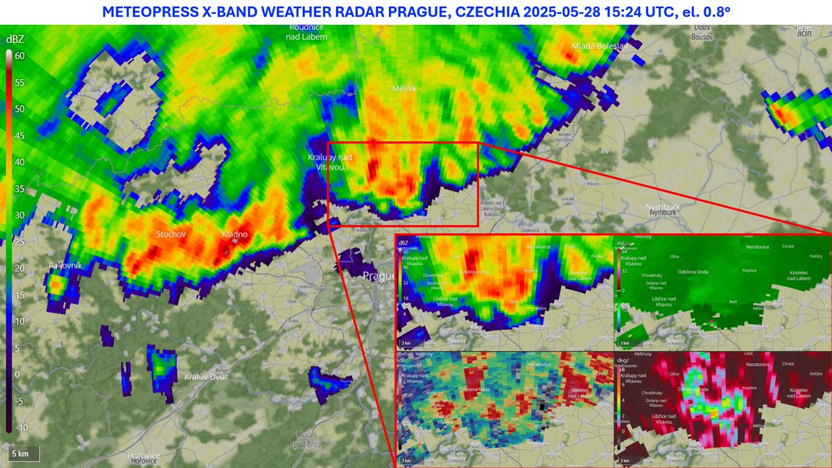
⛈️On Monday, our X-band weather radar currently deployed at a testing site near Prague captured a well-structured storm, which was accompanied by strong wind gusts and also several downbursts.📡

🌩️ On Monday, several supercells developed over Central Europe ahead of a cold front. Here's a vertical cross-section of a right-moving supercell captured by our weather radar located at Hochficht, Austria.

📡Today's cold front, which moved across Czechia, was captured by our weather radar at Hochficht.
⛈️A nice bookend vortex formed in the north part of the squall line in Bavaria on Sunday. Radar image from our weather radar at Hochficht, Austria.📡

⛈️On Sunday, our radar at Hochficht (Austria) captured two squall lines. Multiple small mesovortices formed along one of them.📡

⛈️A severe storm that hit Prague on Sunday was captured by our X-band weather radar, currently deployed at a testing site near Prague. The storm caused strong wind gusts. The highest wind gust, 103.4 km/h, was recorded at the Praha-Karlov weather station.📡

Yesterday, our stormchasers captured this supercell on the German - Czech border.

📡Development of a weak supercell that produced the first tornado in Czechia in 2025.
⛈️Our weather radar in Toulouse, France, captured the formation of a mesoscale vortex on May 19, 2025. The development of the vortex was triggered by a storm accompanied by intense downbursts.📡
⚡️During our first storm chase of 2025, our meteorologists documented a weak squall line that moved through Czechia. The storms were also captured by our X-band weather radar, currently deployed at a testing site near Prague.📡