
Mike Wankum
@MetMikeWCVB
🌩️Meteorologist WCVB-TV Boston. 📺CBM Seal Holder. 🏍️Member NEMRR 👪Happily married father of 3 wonderful children 👶Grandfather to 3 amazing grandchildren
Saturday is the better of the 2 days this weekend. It will be like Friday with comfortable humidity and plenty of sunshine. Sunday features humidity, showers and thunderstorms. We return to comfortable weather next week.

After a stretch of hot and humid days we returned to "average" today. Combined with the low humidity it made for a wonderful July day.

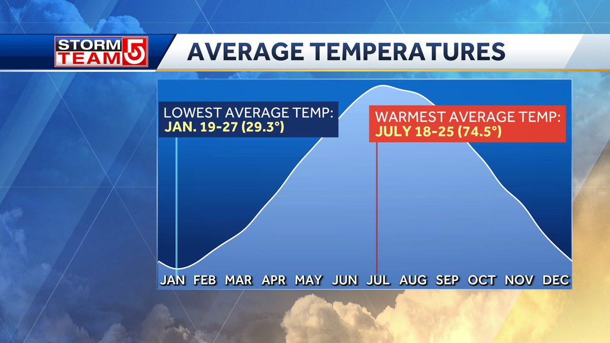
Today begins an interesting date. We begin climatically the hottest stretch of the year. The next week is statistically the warmest of the year, but we already hit 102 back in June. .
Thursday was the last of the 90s. 80s are the rule with lower humidity into next week. Except Sunday when the humidity returns with rain likely.

Friday and Saturday look beautiful with the lower humidity, but the humidity comes back for one day on Sunday and that means a round of showers and thunderstorms.

What do you call them? It's interesting to see what parts of the country call them lightning bugs and which areas call them fireflies. They are harmless beetles that are actually good for your garden. Enjoy.

The humidity will drop along with the temperatures by Saturday. Sunday does have rain with the most likely time in the morning, Season temperatures for most of next week.

It was the second hottest day of the summer today. Second only to the 102 on June 24th.

The best chance for strong thunderstorms will be in central and western Mass on Thursday. Most likely late in the day/evening. Lightning, Downpours and gusty winds are the biggest threat.

To get to the cooler, less humid air we need to go through the rain and thunderstorms to our west. Thursday will be stormy but Friday will be warm and pleasant.
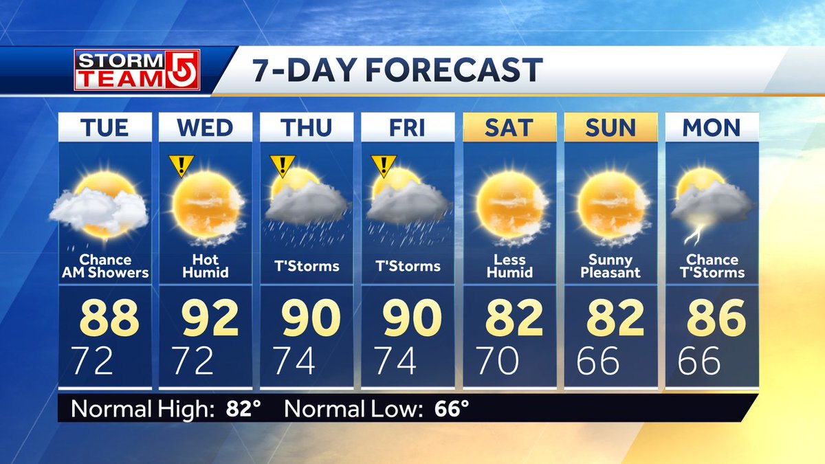
Hot and humid thru Thursday but Friday may transition to lower humidity by afternoon. Less humid weather on Saturday but some showers may sneak into your Sunday plans. Near normal temperatures next week.

An approaching cold front on Thursday will likely trigger afternoon thunderstorms. Lightning, gusty winds and downpours are my biggest concern.

Does it feel more humid to you now then when you were young? If you look at the average summer dew point over the past 90 years you can see an increase. More humid air means bigger rains in summer thunderstorms and warmer temperatures overnight.

Here were the high temperatures today/ Since we did not hit 90 in Boston we have to wait until tomorrow to start a heat wave. An official heat wave in Boston is 3 days of 90 weather.

Hot and humid weather will rule the week. Afternoon thunderstorms are possible Thur and Fri. An early look at the upcoming weekend is for cooler temperatures and lower humidity.
The best chance of thunderstorms this week will be Thursday and Friday afternoon. Less humid air will arrive on Saturday.
A Heat Advisory has been posted for Tues-Thurs and may be extended into Friday. The combination of heat and humidity will make it feel like 95-100. Hydrate and take it easy this week.

Flooding rain in NJ stretched up into western Mass. Goshen MA had 1.99" of rain today. As the storms tracked east they weakened to a few light showers. Almost nothing inside of 495.
Eastern Mass should be dry this weekend with isolated t'storms possible in western Mass. The humidity doesn't go away and we'll turn the heat up next week. Best chances for widespread thunderstorms is Monday and Friday. Isolated t'storms are possible mid week.

Water temperatures are in the upper 60s and low 70s. Looks like a decent beach afternoon on Saturday and Sunday. Boaters be away there may be some morning fog that should burn off by mid morning.
