Journal of Remote Sensing
@JournalofRS
Science (AAAS) partner journal for leading-edge research in remote sensing. We publish original research and review articles, editorials, and perspectives.
🍃Title: Improved soybean mapping with spectral Gaussian mixture modeling 🌱Highlights: Integration of canopy greenness, water content, and chlorophyll characteristics, and use of improved Bhattacharyya Coefficient weights for robust global soybean mapping. 🔑Keywords:…

🌼Highlights: Prediction of Chla concentration changes and water quality management in lakes on the Qinghai Tibet Plateau based on Landsat images and future human activity scenarios (By Prof. Chong Fang) 🔥Keywords: #Landsat images; #ClimateChange; future change; #eutrophication;…
✨Highlight: A new urban 3D reconstruction method enhances Tomographic Synthetic Aperture Radar (TomoSAR) imaging using geometric semantics. By incorporating building structures into a Bayesian framework, the method—Geometric Semantic Enhanced TomoSAR Reconstruction Algorithm…
☀️Producing roughly one-third of global food while hosting the majority of food insecure, smallholder farmers and marginalized communities paradoxically constitute a large proportion of the world’s 735 million chronically hungry people due to systemic vulnerabilities. Hunger…

Quantitative Assessment of the Uncertainty in Aerosol Optical Property Inversion due to Different Surface Reflection Models 🛰️Highlights: A new study improves satellite-based aerosol measurements by assessing how different surface reflection models impact inversion accuracy.The…
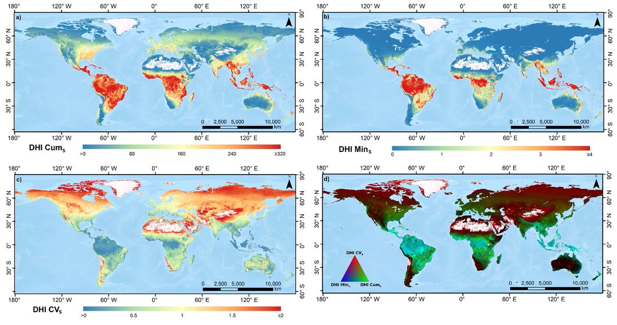
Bridging Satellite Productivity and Global Biodiversity: Unveiling Insights through Dynamic Habitat Indices 🌼Highlights: Dynamic Habitat Indices (DHIs) calculated using satellite productivity measures are powerful and scalable tool for linking Earth observations to global…
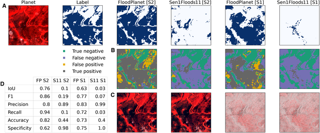
Assessing Inundation Semantic Segmentation Models Trained on High- versus Low-Resolution Labels using FloodPlanet, a Manually Labeled Multi-Sourced High-Resolution Flood Dataset 💡Highlights: This study curates and publicly releases FloodPlanet, a manually labeled inundation…
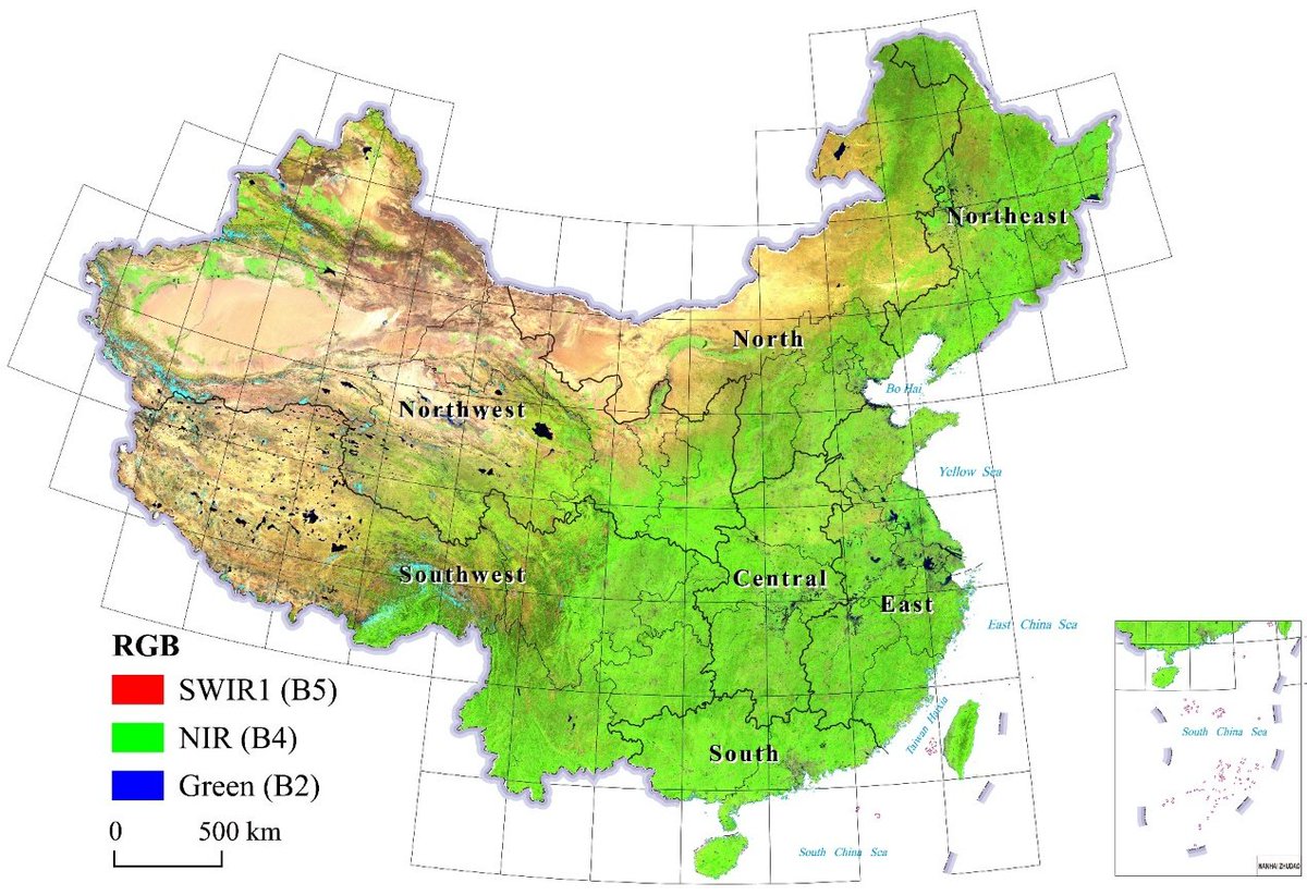
Title: Seamless Annual Leaf-On Landsat Composites for China from 1985 to 2023 💡Highlights: This research developed a long-term, seamless Landsat image compositing method to generate annual cloud-free, Leaf-On imagery for China (1985–2023), enabling nationwide, analysis-ready…
BPUM: A Bayesian Probabilistic Updating Model Applied to Early Crop Identification Highlights: 1⃣This study proposes a Bayesian Probability Update Model (BPUM) for early crop identification. This model combines historical crop planting information and current remote sensing…

A Global Review of Monitoring Cropland Abandonment Using Remote Sensing: Temporal–Spatial Patterns, Causes, Ecological Effects, and Future Prospects 🌼Highlights: This work systematically reviews remote sensing-based methods for monitoring abandoned cropland, including its causes…

💡Highlights:This study developed a simple and efficient multispectral remote sensing index, the Spartina alterniflora Index (SAI), which enhances the spectral contrast between red and near-infrared bands to enable accurate identification of small patches of Spartina…

⚡️Highlights: In this study, we pioneered the Seasonal Tree Height Neural Network (STHNN) integrating multi-source remote sensing data and SHAP optimization, and realized the dynamic seasonal monitoring of tree height in Shenzhen (R²=0.80, MAE=1.58 m), revealing the seasonal…

Title: Unsupervised Cross-Regional and Cross-Year Adaptation by Climate Indicator Discrepancy for Crop Classification Highlights: 1⃣A novel index was designed to quantify regional climate conditions, establishing a link between climate difference and spectral shift. 2⃣A method…

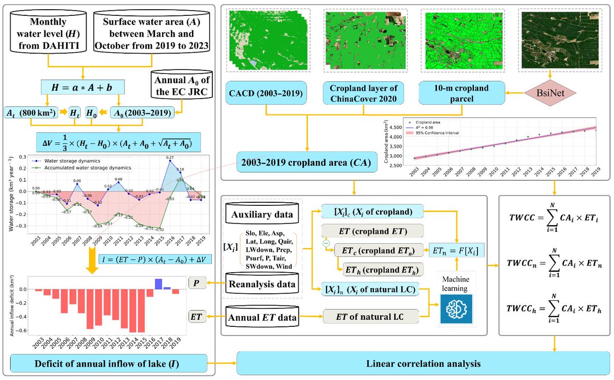
👉Title: Increasing Cropland Area and Its Associated Human-Induced Water Consumption Put Ebinur Lake at Risk of Drying Up ⚡️Highlights: A data-driver model designed to successfully quantify the contribution of natural and anthropogenic drivers on cropland evapotranspiration (ET)…
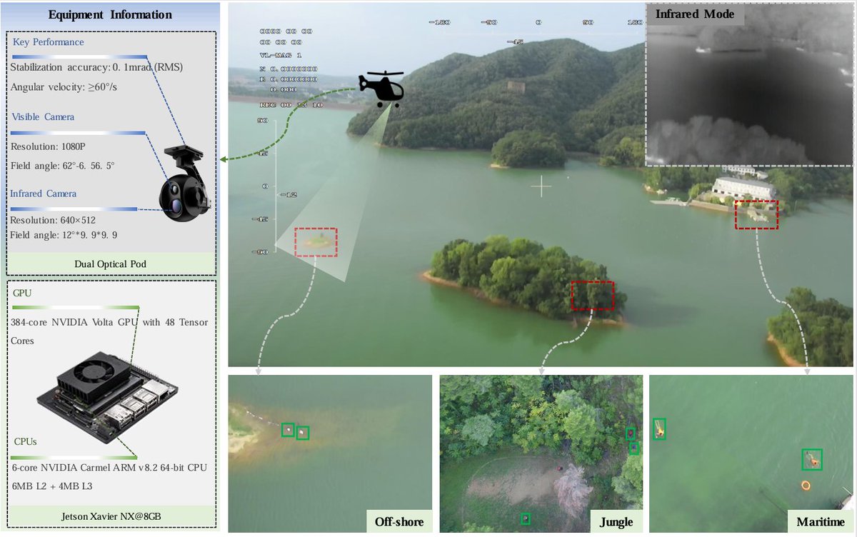
✈️Aerial Person Detection for Search and Rescue: Survey and Benchmarks 1⃣ First systematically evaluated the accuracy of deep learning models in the task of aerial person detection. 2⃣ Constructed a comprehensive benchmark testing framework that covers various aerial test…