ECCC Weather Ontario
@ECCCWeatherON
Canada’s official weather and climate source. Tweets by @environmentca meteorologists. Suivez-nous en français @ECCCMeteoON Terms: http://ow.ly/yBnM30le8Za
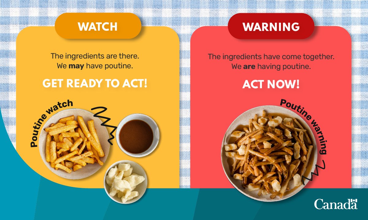
Are you prepared for thunderstorms ⛈️? Remember to check for severe weather alerts here 👉 ow.ly/l6cF50VLsIB and your local forecasts here ➡️ ow.ly/Z5jS50VLsIC ‼️Don't forget🤔 the difference between severe weather watches and warnings👇👇👇 #ONStorm #ONWx
Several parts of Ontario could experience severe thunderstorms today ⛈️ ⛈️ Check these tips to stay safe during a severe thunderstorm 👇 Follow your local alerts here 👉 ow.ly/VWHb50WuAXA #ONstorm #ONwx #weatherwise
Many people take advantage of the holiday season to go camping, visit lakes and rivers, or go hiking. However, when there is potential for thunderstorms, it is important to stay alert to their development. Here are a few recommendations 👇#QCstorm
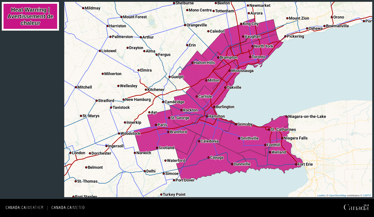
A heat warning has been issued for portions of southern and northeastern Ontario for hot and humid beginning Sunday. 🌡️ Daytime highs of 29°C to 34°C. 🥵 Humidex values of 38 to 42. 🌡️Overnight lows of 19°C to 23°C. Details 👉ow.ly/5Bwq50WvGkS #ONwx

🌤️Significant weather outlook for Sunday-Wednesday ☁️Poor air quality is expected to persist over most of NW and NE ON tomorrow. 🌫️ 🌡️Heat will begin in the NE tomorrow until Monday, and a heat event in southern ON will last until Wednesday. #ONstorm #ONwx


⚡Thunderstorm outlook for Sunday & Monday.⛈️ Thunderstorms are expected over parts of northern and southern Ontario. 🌩️ 🌬️Wind, hail, rain, and a tornado risk are possible over parts of NW ON on Sunday and parts of NE ON on Monday. ☔ #ONstorm #ONwx


⛈️ A severe thunderstorm watch is in effect for portions of northern and far northern Ontario. Hazards: Wind gusts of 90 to 110 km/h Hail 2 to 4 cm in diameter. Heavy downpours. Timing: This afternoon and evening. 🔗 ow.ly/Jxis50WvF2p #ONstorm #ONwx

Thunderstorm outlook for today. ☔ ⛈️Thunderstorms are expected across parts of northern and southern Ontario. 🌩️ 🌧️Some storms in SW ON could produce strong winds and rain. Strong winds, rain, hail, and a tornado risk are possible for parts of N ON.🌪️ #ONstorm #ONwx

A heat warning has been issued for portions of northwestern Ontario for hot and humid conditions today through Sunday. 🌡️ Daytime highs up to 29°C. 🥵 Peak humidex up to 38. 🌡️Overnight lows near 19°C. Details 👉ow.ly/eyYy50WvEGn #ONwx

⚠️ An updated look to the Air Quality Alerts! Poor air quality is expected to continue today and possibly through the weekend across portions of northern and far northern Ontario due to smoke from wildfires. Details 🔗 ow.ly/8aB650WvEnQ #ONWx #ONSmoke

⚠️ Air quality alerts have been expanded across parts of northern Ontario as smoke from wildfires brings very poor air quality to the area. Read more about how to protect yourself in our alerts here 👉 ow.ly/XKwo50WvAlF #ONwx

⚡Thunderstorm outlook for this weekend.⚡ ⛈️Thunderstorms are expected over portions of northern and southern Ontario. 🌬️Some storms in the NW and far NW could produce strong winds, hail, and rain. ☔ #ONstorm #ONwx


🌤️Significant weather outlook for Sat-Tues.☁️ ☁️Poor air quality is expected over parts of northern and southern Ontario this weekend. 🌫️ 🌡️Heat is expected to arrive Sunday for parts of southern Ontario and is also possible in northern Ontario this weekend. ⛱️ #ONstorm #ONwx


A heat warning 🌡️ in effect for portions of the Greater Golden Horseshoe will end tonight. After a cooler day Saturday, heat is expected to return to a large swath of S ON in the Sun to Tue timeframe. Ensemble temp. model guidance is shown, courtesy of @weatherbell 👇 #ONwx


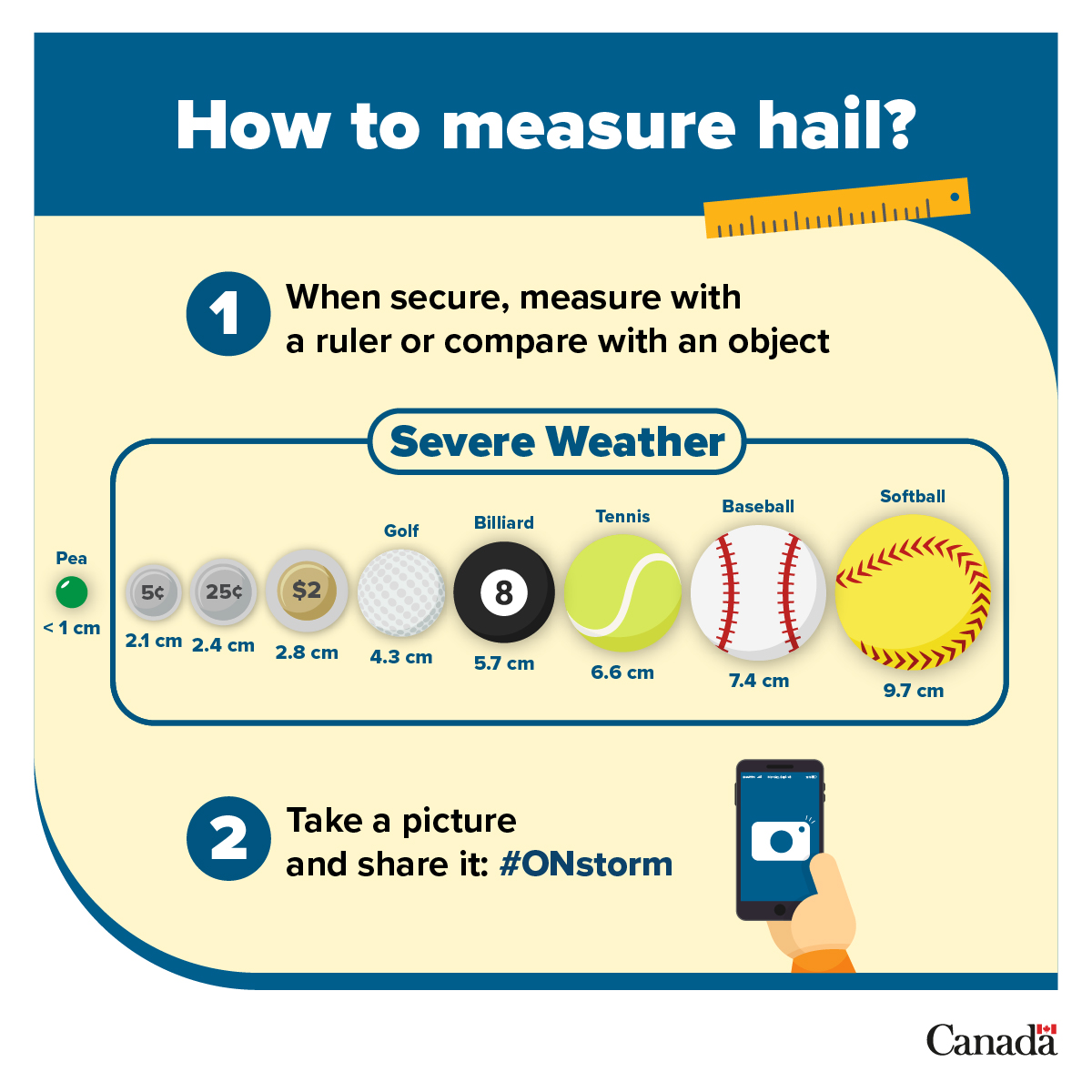
There are some reports of hail from yesterday's storms in southern Ontario. This is how to report it: 👇 #ONwx
🌧️Thunderstorm outlook for today.🌩️ ⚡Thunderstorms are possible over portions of NW, far NW, and SW Ontario today. #ONstorm #ONwx

☀️Significant weather outlook for Fri-Mon🌤️ 🌫️Poor air quality is expected for portions of N ON Fri and Sat. 🌡️A heat event across S ON will continue through Mon, while a heat event is expected to begin in portions of NE and NW ON on Sun. #ONstorm #ONwx


☔Thunderstorm Outlook for Friday-Saturday👇 🌧️Fri: Thunderstorms are possible for portions of southern, NE, and NW Ontario. 🌩️Sat: Thunderstorms bringing wind, rain, and hail are possible across northern and far northern Ontario. #ONstorm #ONwx


An updated look at the current ⚠️ ALERTS ⚠️ for southern and northeastern Ontario! ⛈️ Current Severe Thunderstorm Watches & Warnings and Tornado Watches & Warnings can be found 👉 ow.ly/Rr2650WuUqU #ONStorm #ONwx

A heat warning is in effect for parts of the Golden Horseshoe. 🌡️The humidex shows how hot it feels with heat and humidity. ✅Stay hydrated and watch for signs of heat exhaustion or heat stroke. #ONwx

⛈️Thunderstorm outlook for today.🌩️ Thunderstorms are expected for southern, NE, and portions of NW ON this afternoon. ⚡ 🌬️Storms in NE and S ON could produce strong winds, hail, and rain. 🌧️ 🌪️There is a tornado risk for portions of NE and southern ON. #ONstorm #ONwx

Hot conditions are expected across much of southern Ontario tomorrow. A heat warning has been issued for portions of the Golden Horseshoe for hot conditions through Friday. 🌡️ Daytime highs up to 35°C. 🥵 Peak humidex up to 44. Details 👉 ow.ly/EGqF50WufGP #ONwx