Chase Wilson
@DualDoppler
Meteorologist/Radar Analyst @tnvalleyweather • I have an X-band, and I’m not afraid to use it • Working to fill the TN Valley Radar Gap
ICYMI: My Stations dual-pol, rapid-scanning X-band Radar is now PUBLIC for all to view in GR2Analyst. Add the below info to your customradars.gis - FWLX, FWLX, 35.254963, -87.325317, 220, 1, TN, WLLX X-Band Restart GR2, and boom! Live data achieved! #tnwx #alwx
Found some exposed Ordovician fossils in rural Lawrence County, TN today in one of the many exposed cores of hill ls that are cut out when building highways in hilly terrain. It always pays to take a peek inside the layers of these cliffs… they tell a story of millions of years!


Beautiful roost rings this morning as birds take off and start their day, as seen on KHTX NEXRAD
It’s nice to see my colleagues waking up to alternatives in the space of broadcast meteorology - often alternatives on our own terms. Big news media knows the old ways are dying & are stretching its employees thin to a breaking point - endemically so. I’m sure they know it too.
Most people across the U.S. have no idea of the Alabama tornado tragedy that happened on April 27, 2011. A total of 62 tornadoes in one day, responsible for the deaths of 252 people in our state. A few days later, Osama bin Laden was killed. Weeks later, an EF-5 tornado wiped…
while storms were ongoing to the south last night, a time-combined view from our X-band over 15 minutes shows the track of two Chinook helicopters flying by. There's always more than just precipitation on many radars if you know where to look!

Nothing beats being at the forefront of this with my team at @tnvalleyweather under the National Weather Network. This is the way forward
Take notes, young weather enthusiasts / meteorologists. Several states still need this. The door is WIDE open.
This boggles the mind. Any 1 tiny decision along the road to today could have saved these people’s lives; instead we got the decision to build in a floodplain, to ignore forecasts and warnings(!), to ban electronics on-site… disasters are usually such because of negligence.
Most of the main buildings were located in the regular floodplain, meaning any flood would be a significant issue. Not even the 1% or .2% which this one reached.
This is why we can’t let this lunacy fester. Radars. Are. Tools. Not. Weapons. I’m sure this is one of those crazies that did this. The confluence of our failing education system and mental health crisis only gets worse by the day, and this is the end result.
A vandal knocked out News 9’s weather radar in OKC—then took out the cameras, but not before one got his face. Here are the details: news9.com/story/686c1415…
Looking back at the ARMOR data from the 5/20 tornado near Tanner, AL that prompted a tornado emergency for portions of Madison and Huntsville, it really shows you their reasoning for that TORE - KHTX was too coarse and too distant, but ARMOR was a positively spooky signature.

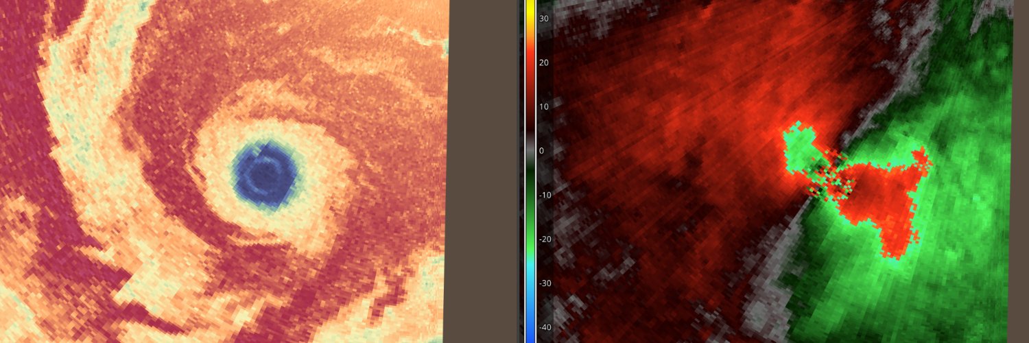
Well that’s something you don’t see every day, and proof why you should NEVER rely on your most baseline knowledge of radar to prognosticate tornadoes. A TDS that is disjointed, associated with nothing but what SEEMS to be light showers, and effectively no couplet on velocities !

Even though dual-pol is still relatively new to NEXRAD (that is, having been fully installed for ~12 years of NEXRADs 35 years), dual-pol itself is no spring chicken. Here’s some zdr/reflectivity data from 1983 (with early experiments going back even to the mid-1970s)!

With recent tornado reports coming in, 2025 is now, to date, the most active tornado year since 2011

Didn't take long until we got the example of a lifetime of non-uniform beamfilling last night... if you see a CC drop far from radar, behind heavy precip... check your work... match against differential phase shift (phi) to find downradial attenuation sources b4 you call a TDS!
@DualDoppler I need you, AMERICA needs you to tell some of these people that Non-Uniform Beam Filling is NOT debris in the CC data. Godspeed, Godbless. Vaya Con Dios.
This single-gate tornado with a subtle TDS likely just impacted a few chasers who it took by surprise. Important to work in the constraints yr given @ night, in this case the resolution of NEXRAD... shallow/narrow vortexes in turbulent environments does not a safe chase make

I’m not sure if this is a tornado or not near Almont, North Dakota, but honestly with winds of this magnitude i’m not sure it matters. Maybe the strongest unambiguous wind swath signal i’ve ever seen on NEXRAD

Found a small path of damage from the intersection of Crews St and Massey in Lawrenceburg, to the intersection of Martin and Weakley Creek Rd. A couple snapped trees, and an under-construction frame toppled. Couplet was very visible on our X-band just 100 yds away! @NWSNashville


Absolute tornado mayhem in Illinois right now, I am absolutely baffled. Just as soon as one is warned, ANOTHER unwarned massive TDS blossoms, this time nearing Pleasant Plains IL!
Incredible totally disjointed TDS continues in Ashland. Shockingly, still no warning on this one