Collin Gross
@CollinGrossWx
Meteorologist • Severe Weather Enthusiast • Photographer 📸☀️⛈️⚡️
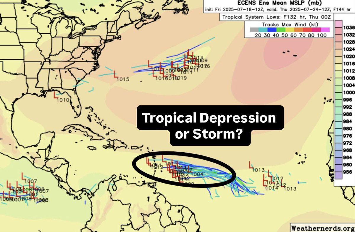
Some tropical trouble late next week in the Atlantic? Euro Ensembles showing a wave moving into the MDR (Main Development Region) and developing into a depression or storm. Conditions overall are very hostile to support a storm, but a Kelvin wave could help support convection.
Sea breeze and outflow boundary colliding near Panama City, Florida which sparked thunderstorms this evening. #FLwx
Visible satellite showing a swirl of clouds moving through Nebraska and into Iowa this afternoon. That’s an MCV (Mesoscale Convective Vortex) which spun up from the intense thunderstorm complex in Kansas last night.
Check out this incredible visible and infrared satellite loop of intense thunderstorms erupting in Kansas tonight. The cloud tops of these storms are very COLD, nearing -90°C! #KSwx
Visible satellite loop showing an intense cluster of thunderstorms moving through north-central Kansas tonight. You can see the bubbling cloud tops, some of which are reaching 60,000 feet. Several 60-75+mph wind gusts recorded. #KSwx
Who’s ready for some LOW humidity in the Northeast?! A strong cold front is on the way and will drop dew points from the muggy 60’s and 70’s to the dry 30’s and 40’s. Comfortable conditions expected Monday-Wednesday.
MCS (Mesoscale Convective System) diving through Iowa this morning producing heavy rain, damaging winds, and lots of lightning. #IAwx
Awful news out of Jackson, New Jersey this evening. At least 13 people were struck by lightning at Black Knight Bow Benders Archery Club. Sadly at least 1 fatality confirmed. #NJwx
#Invest93L a disorganized mess this morning with the center over north Florida and convection over the Gulf. It looks increasingly unlikely we get anything tropical out of this, but that doesn’t mean heavy flooding rains won’t be a problem.
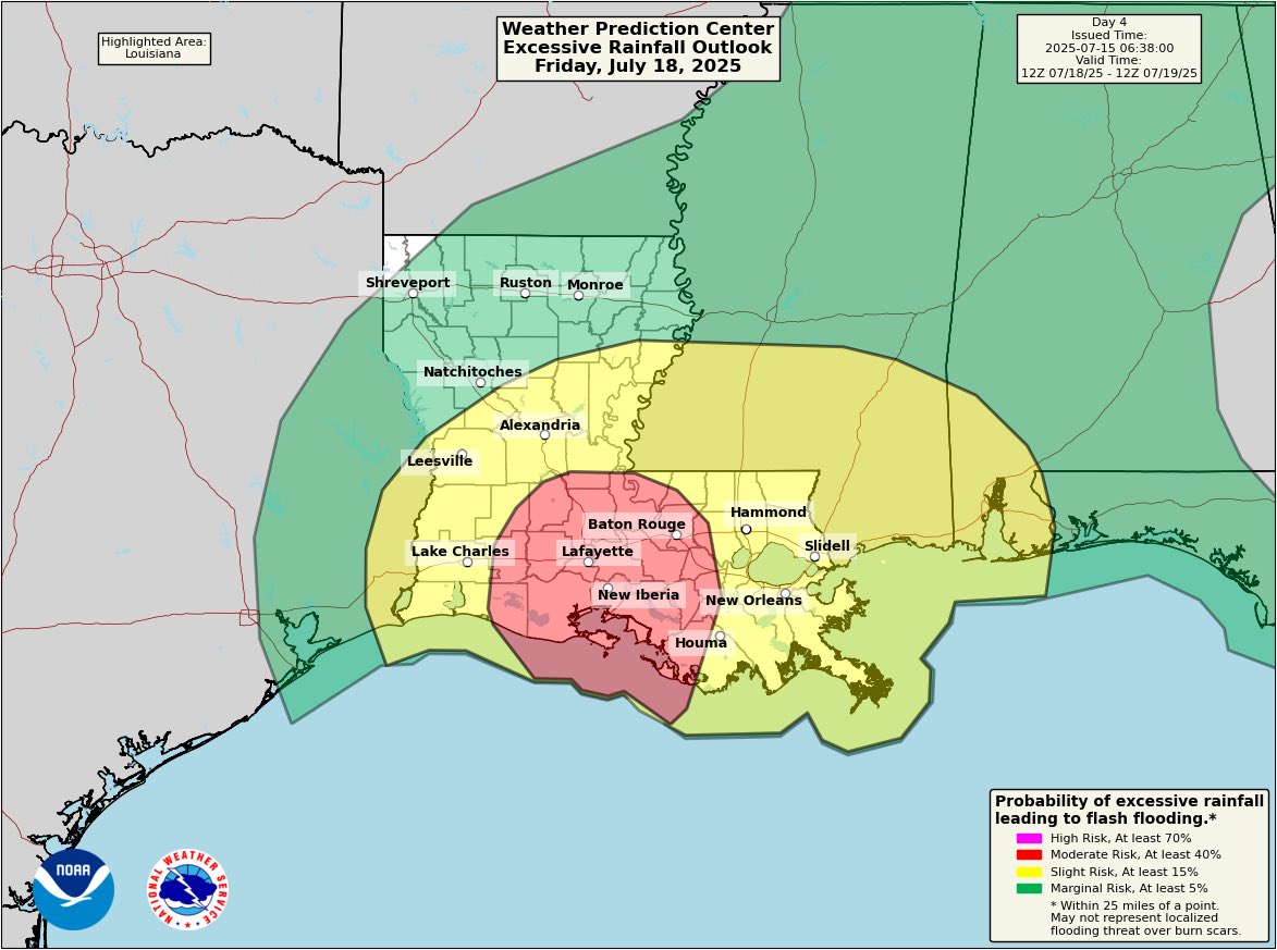
The Weather Prediction Center has put out a rare Day 4 Moderate Risk of flash flooding for south-central Louisiana. #Invest93L will bring lots of heavy rain to the area late in the week. #LAwx
Visible satellite loop showing #Invest93L approaching north Florida today. National Hurricane Center giving this a 40% chance of tropical development as it moves into the Gulf. Regardless of development, this will be a heavy rain maker for much of the Gulf Coast. #FLwx
BREAKING: Sadly 2 people were killed from flash flooding yesterday in Plainfield, New Jersey. Their vehicle was swept into Cedar Brook.
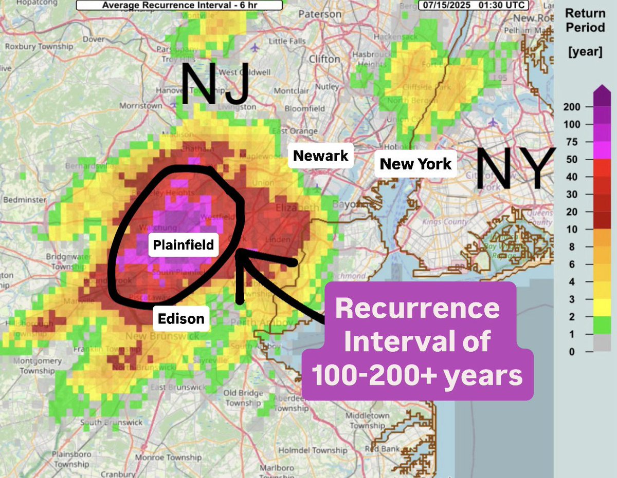
Significant flash flood event today in parts of Somerset, Middlesex, and Union Counties in New Jersey. Radar estimating 5-7 inches of rain fell in just a few hours leading to road closures and water rescues. Average Recurrence Interval is 200+ years around Plainfield. #NJwx
Family friend sent me this video of a significant flash flood in Somerville, New Jersey. #NJwx
Waterfront property in Clark, New Jersey Waves on my front lawn 👀🌊⛈️ #NJwx
Bad flooding here in Clark, New Jersey…the 2nd one of the day. The red car stalled out. #NJwx
⚠️⛈️ There is a Moderate Risk (3/4) of excessive rainfall leading to flash flooding beginning this afternoon into tonight. Numerous flash floods can be anticipated across portions of the region due to scattered thunderstorms producing heavy rainfall. #PAwx #NJwx #DEwx #MDwx
Significant flash flooding occurring in Newark Valley, New York tonight after storms dumped nearly half a foot of rain during a short period of time. Reports of several people being rescued from their residences with water up to first floor windows. #NYwx