Cody Matz
@CodyMatzFox9
Meteorologist at Fox9 in the Twin Cities. Minnesota native, snow lover, Crossfit addict, pun appreciator, laugher of stupid humor...
Any super heavy rain is looking less and less likely in the Twin Cities as a cluster of stronger storms take hold in southwestern MN. Saying that, flash flooding chances continue to increase along I-90. Already nearly 4" reported in Marshall...
Another summer night, more flash flooding possible with any storms that linger a little too long in one spot. Pockets of 2"-5" of rain will be possible through the overnight inside the dashed pink circle which could include parts of the Twin Cities metro...
Another summer night, more flash flooding possible with any storms that linger a little too long in one spot. Pockets of 2"-5" of rain will be possible through the overnight inside the dashed pink circle which could include parts of the Twin Cities metro...

Flash flooding is likely in some areas inside this pink area... which essentially covers the current Severe Thunderstorm Watch...
#WPC_MD 0700 affecting Upper Midwest, #miwx #wiwx #mnwx, wpc.ncep.noaa.gov/metwatch/metwa…
Severe Thunderstorm Watch possible from roughly Willmar to St Cloud, Brainerd, Pine City to Duluth & northwest WI as storms become more numerous over the next few hours...
12:50pm CDT #SPC_MD 1674 , #miwx #wiwx #mnwx, spc.noaa.gov/products/md/md…
Okay @Delta … it’s time to retire your 717s. My flight today is significantly delayed because the plane is broken and we have to get a new one. Every flight I’ve taken in the last 2 years on these aircraft, there’s been a problem. Never an issue any other time. 👎👎
Flash Flood Warning now for parts of the northwest Twin Cities metro from Maple Grove to Blaine. 2"+ of rain has fallen in the last hour or so with more still going. More heavy rain arriving to other parts of the metro now as well...
Severe Thunderstorm Warning now from Nisswa to McGregor for 60+mph winds and half dollar size hail…
That is a bow! Thankfully doesn’t appear like any of the stronger gusts are reaching the ground. Hopefully it stays that way as this moves through the Twin Cities over the next couple hours
Here is the strongest of the storms in MN tonight, and quite likely will grow into an anticipated line of stronger storms that pushes south and east through parts of southern MN and then into Iowa overnight. This will likely house very heavy rain and strong winds...
Rain, thunder, and lightning pushing through the Twin Cities metro now. Most of this is weakening as it rolls through, so anything severe is very unlikely, but some downpours and even small hail will be possible as this moves through...
This storm with the potential for golf ball size hail is still going strong... new Severe Thunderstorm Warning from Clara City to just about Willmar in western MN...
New Tornado Warning issued for areas northeast of Cottonwood in southwestern MN... this is radar indicated rotation, but areas from Hanley Falls to Wood Lake should be in your tornado shelter...
New Severe Thunderstorm Warning issued for areas around and just north of Granite Falls in western MN. Golf ball size hail will be possible over the next half hour or so...
The 52° in the Twin Cities this morning was the coldest temperature in July since 2016. We also tied a daily record low (although it is the warmest daily record of the year). A daily record low hasn't occurred in the summer months in the Twin Cities since August 2004.

High temps haven't been that abundantly hot this summer in much of the U.S. but, overnight lows have been quite warm in some areas. The Ohio Valley to New England, many climate zones experiencing the top 5 warmest lows for the first half of summer since 1893. MN has been avg-ish

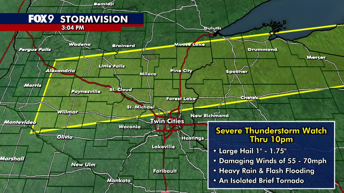
A Severe Thunderstorm Watch has been issued thru 10pm for areas in the northern Twin Cities metro northward...including many areas from Alexandria to St Cloud to Duluth. Gusty winds & flash flooding will be the main threats, but large hail & an isolated tornado cant be ruled out
Heat advisory issued for Tuesday in the Twin Cities metro for a heat index up to ~100°. While it will be fairly brief, it's the fact that there will be very little relief as we head into tomorrow, with overnight temps only falling to the mid to upper 70s. #StayCool

That's a code purple for the northern half of MN... meaning VERY poor air quality is likely at times. Just remember the smell test.. if it smells like smoke or just plain gross, then the air quality is unhealthy, especially for an extended amount of time...
An Air Quality Alert for wildfire smoke has been expanded to all of Minnesota and extended through 9am Monday, July 14th. Find additional details at pca.state.mn.us/air-water-land… #mnwx #aqi
Air Quality Alert just issued for the entire state of MN thru the weekend. Ground level Canadian wildfire smoke will sweep across the state tonight, & then wax & wane over the weekend. The worst air will be across northern MN, but all of us will deal with unhealthy air at times.


A broken line of storms firing up in central & western MN along a cold front pushing eastward. While widespread severe weather is NOT expected, a couple of these storms could end up a lil punchy into this evening as they flourish and fade rolling toward the Twin Cities...